Haiti Environment (19/04/2016)
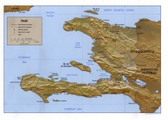
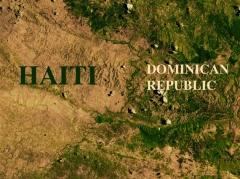
Haiti is an island between the Atlantic Ocean and Caribbean Sea. Haiti has a border with the Dominican Republic. This Island has an area of 27,750 square kilometers. Its capital, the largest city, is Port-au-Prince, it is locates in the country’s southwest coast.
Deforestation:
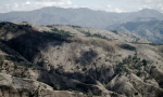
Haiti is covered by mountains and forests but with the pollution of fuel, there is a big deforestation. 30m to 40m trees a year are cut down. Haiti has the highest rate of deforestation of any country in the world. It’s an impact on social economy. With the deforestation, agricultural development can’t progress, so rural communities, who live through farms, can’t earn money. This makes a cycle of poverty in the country. Degradation of water resources and habitat destruction also come from deforestation.
To fight this problem, the government and some associations made some campaign, Government decide to plant 50m trees a year. The environment minister makes it because Cuba made the same thing and it worked (to have a new forest). Hilary and Bill Clinton gave money to save national parks of Haiti. There are 67 protected areas including 16 national parks. It's important to collect money with tourism in these parks to save the other forest in the island.
Highest mountains:
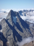
In the national park, there are many high mountains:
-Pic la Selle: 2,680 m
-Pic de Macaya: 2,347 m
-Morne Bois Pin: 2,241 m
-Morne Kadeneau: 2,145 m
-and others.
The La Selle pit with a beautiful weather:
14:42 | Lien permanent | Commentaires (11)
Commentaires
Super début!! Je kiffe vivement la suite!!
Écrit par : anonyme | 19/04/2016
Moi aussi!! J'ai hâte de lire la suite!
Écrit par : anonyme | 21/04/2016
Merci pour vos compliments nous avons encore pleins d'articles en cours de rédaction qui vont bientôt arriver
Écrit par : Laure | 25/04/2016
Je suis très agréablement surpris que des élèves de troisième puissent écrire des articles aussi pertinents que celui-ci en anglais en plus. J'espère que vous continuerez ainsi.
Écrit par : anonyme | 21/04/2016
Merci pour votre compliment sur la qualité de notre anglais et ne vous inquiétez pas ce blogue va tourner au moins jusqu'à la fin de l'année.
Écrit par : Laure | 25/04/2016
Ce blog est vraiment génial et intéressant! Les articles sont très bien écrits. Bravo!
Écrit par : Carla | 23/04/2016
Comme tous les articles que j'ai pu lire jusque là, celui-ci est très pertinent et très bien fait. Je me réjouis d'avance pour les prochains articles
Écrit par : Françoise | 23/04/2016
Merci pour vos encouragements.
Écrit par : Laure | 25/04/2016
Comme tous les articles que j'ai pu lire jusque là, celui-ci est très pertinent et très bien fait. Je me réjouis d'avance pour les prochains articles.
Louis S.
Écrit par : Françoise | 23/04/2018
Superbe blog, continuez ainsi. Félicitations à tous.
Écrit par : Louis So | 25/04/2016
Superbe blog, continuez ainsi. Félicitations à tous.
Écrit par : Louis So | 25/04/2016